| Geological Institute RAS |  |
||
| tel.: +7(495)230-8029, fax: +7(495)951-0443 | |||
| e-mail: gin@ginras.ru | |||
|
перейти
на русский
|
|||
FIELD-WORK AREAS
Employees of laboratory carried out the field investigations on Kamchatka,
Koryak Upland, Novosibirsk Islands, and Crimea. Besides, the materials from
South-Anui zone (Western Chukotka) and Far East were work up. The main field
areas are Kamchatka and south part of Koryak Upland.

|
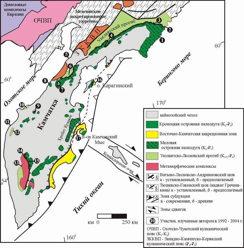
General geological setting of Kamchatka in the Russian Far East.
Numbers in black circle marks the studied locations. 1 - Cape Vitgenshtein, 2 - Anastasia Bay, 3 - Ilpi and Matysken Rivers, 4 - Tapel'vayam River, 5 - Cape Tevi, 6 - Shamanka Dome, 7 - Vatapvayam Dome, 8 - Palana River, 9 - Rassoshina River, 10 - Omgon Range, 11 - Cape Hairuzova, 12 - Moroshechnyi Range, 13 - Krutogorova River, 14 - Oblukovina River, 15 - Left Andrianovka River, 16 - Karaginskii Island, 17 - Kumroch Range.
History of field study of Kamchatka and Koryak Upland
1993 - Machevna River (Olyutorskii Range, south part of Koryak Upland) (Ledneva, Soloviev, 1999[9]), Vitgenshtein Cape (Bogdanov et al., 1999; Soloviev, 1996; Kovalenko et al., 1996[6]).
Vitgenshtein Cape
![]()
1994 - Anastasia Bay (Olyutorskii Range, south part of Koryak Upland ) (Soloviev et al., 1998; Soloviev, 1998[13])
Jasper with inoceramus (Vatyna Group)
Pillow-basalt (Vatyna Group)
![]()
1995 - Il'pi and Matysken Rivers (south part of Koryak Upland ) (Soloviev et al., 2000; Soloviev et al., 2001)
The Flysch (Ukelayat Supergroup)
Vatyna-Vyvenkskyi thrust
![]()
1996 -Tapelivayam River (south part of Koryak Upland ) (Soloviev
et al., 2001).
![]()
1997 - Vatapvayam Dome (the Isthmus, Northern Kamchatka) (Shapiro,
Soloviev, 1999; Soloviev et al.,
2001).
The flysch (Lesnaya Group)
Chert (Irunei Group)
![]()
1998 - Omgon Range (Western Kamchatka) (Bogdanov et al., 2003[2];
Soloviev et al., 2005)
The tectonic block, basalts
Babushkin Cape
Rassoshina River.
![]()
1999 - Shamankinskiy dome (the isthmus, Northern Kamchatka) (Soloviev
et al., 2001; Soloviev et al.,
2002)
Folds in siliceous olistoliths, northwards of Palana River
![]()
2000 - Karaginskii Island (Eastern Kamchatka) (Shapiro et al., 2004).
Hairuzova Cape, Moroshechnii Range (Western Kamchatka).
Folded
rocks, the Upper Oligocene - Lower Miocene, Hairuzova Cape, Western Kamchatka.
![]()
2001 - the Platonich River and Baraba Mountain area (The Sredinnyi Range, Kamchatka), (Soloviev et al., 2004).
Baraba Mountain
The Kumroch Range and Kamchatskii Cape Peninsula (Eastern Kamchatka), (Soloviev
et al., 2004).
The flysch (Drozdovka Group, the Kumroch Range)
The cut-off structure in the flysch (Tushevka Basin, Eastern Kamchatka)
The uplifted erosion surface (Kamchatskii Cape Peninsula)
![]()
2002 - The Krutogorova River and Left Andrianovka Rive (The Sredinnyi Range,
Kamchatka) (Kirmasov et al., 2004;
Hourigan et al., 2004).
The Sredinnyi Range, The Krutogorova River
The Left Andrianovka River
![]()
2004 - The Kolpakova River (The Sredinnyi Range, Kamchatka)
The Sredinnyi Range, The Kolpakova River
![]()
